ArcGIS For Local Government
"EI Technologies is certified ArcGIS for Local Government partner"
For ArcGIS for Local Government. We are now offering packaged solutions to get your implementation up and running in a record time. We call this our “Efficiency Implementation Booster (EIBoostTM)”. Download PDF Brochure for our ArcGIS for Local Government offering.
EIBoostTM – Efficiency Implementation Booster
EIBoostTM allows an end user to implement ArcGIS for Local Government quickly and efficiently. EIBoost will jump start your implementation and allow you to show quick success throughout the organization.
EIBoostTM is available in three different packages:
EIBoostTMLite – This is our most affordable service. As part of this package we will perform a quick data mapping between your current database and the Local Government Information Model (LGIM). Next, we will customize the LGIM if there are any additional features or fields necessary. We will then migrate your data into LGIM. You are now ready to take advantage of everything ArcGIS for the Local Government Information Model has to offer along with ready to use maps and applications.
EIBoostTM Standard – This is our most popular implementation service. As part of this package, you get everything that is outlined in EIBoostTM Lite. In addition, we will also setup up to ten maps for your staff to use from day one. We will also implement two desktop applications and two web applications for ArcGIS for Local Government.
EIBoostTM Premium – This is the most advanced service levels that we offer. As part of this package, you get everything outlined in EIBoostTM Lite and EIBoostTM Standard. In addition, you also get ten more maps and two more desktop applications, as well as three more web applications. With this package, you also get an unlimited license to our CAMPSTM suite of products outlined on this page.
ArcGIS for Local Government Applications
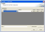
CAMPSTM Email Notify
 This desktop application allows administrators to set up notification emails that will be automatically generated and sent out to the designated personnel when a specified attribute of a feature class is populated or modified. It will help data maintainers and GIS supervisors keep track of key information changes so to improve the data maintenance workflow.
CAMPSTM Email Notify has two components:
- ArcCatalog tool that can be used to set up the application configurations that include:
- Geodatabase the application will apply to.
- When an attribute of a feature class is changed, emails will automatically be generated and sent out.
- Email Subject and body message.
- Recipient emails.
- ArcMap editor extension that will generate and send out emails when a specified attribute of a feature is populated or updated.
CAMPSTM Centerline QC
This desktop application will help validate street centerline address range. It will check the following validation rules:
- For any single segment, the From range must be less than the To range. Check for both left and right addresses.
- For any single segment, both left ranges must be either odd or even, and both ranges on the right must be either odd or even.
- For any single segment, one side of the street must be even and the other side must be odd.
- For all segments with the same street name, no 2 segments can have overlapping ranges.
- For all segments with the same street name, ranges on the left or right must be consistently odd or even.
- For all segments with the same street name, the end point of a single segment must connect to the beginning point of another segment.
- It is acceptable if an end point or beginning point does not connect to another end point or beginning point.
When conducting validation, the user can choose to validate only selected street centerlines, or all centerline data. The user can also set up exception to exclude some centerlines from validation. The validation report will be generated for review.
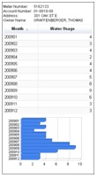
CAMPSTM Water Usage Report
 This is a web based application module that allows managers to review water usage in a dashboard environment. This application offers access to monthly water usages for single meter or accumulative water usages for all meters in tabular and chart format. The water usage report can be generated for printout.
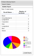
CAMPSTM Incident Report
This is a web based application module that allows managers to review a variety of incidents including water breaks, sewer backups, crime incidents, pot holes and any other published incidents in a dashboard environment.
The application will search for all the incidents of one type based on the geographic area (either a feature of a boundary layer, or a graphic drawn on the map), and the date range the user provides. The result will be displayed in an incident table. The incident distribution will be displayed on the map. If the incidents can be categorized, the application will return a summary table showing the total occurrences of each incident category, and a pie chart of the occurrence proportion of each incident category. Clicking on one category in the table will return the incident list of that category. Each incident details can be accessed by clicking the incident feature on the map.
 The incident report can be generated for printout.
